|
|
|
Clark County Press, Neillsville, March 7, 2007, Page 17 Transcribed by Dolores (Mohr) Kenyon. Index of "Oldies" Articles
Compiled and contributed by Dee Zimmerman
Clark County News |
|
|
|
Clark County Press, Neillsville, March 7, 2007, Page 17 Transcribed by Dolores (Mohr) Kenyon. Index of "Oldies" Articles
Compiled and contributed by Dee Zimmerman
Clark County News |
March 1877
Sleighing has not been better the present winter, than this portion of the beginning of March.
•••••••••
Young men in these parts, in sowing their wild oats, are apt to mix too much old rye with them.
•••••••••
The winter term of Joint District No. 1 School, towns of Pine Valley and Levis, closed one week ago, last Saturday, with a fine exhibition in the evening. The scholars of the school acquitted themselves in their exercises in a manner entirely satisfactory to parents and their teacher. This showed that neither scholars nor teach had been idle during the past four months. The schoolhouse is large and comfortable and it was crowded to the utmost. (Could anyone tell us where this school was located? Dmk)
•••••••••
Those having cows running loose in the village streets, complain that farmers do not have sufficient grain and hay in their sleighs when they come to town, with which to keep their cows well fed.
March 1937
(Fred Draper, who lived at Loyal, compiled a “History of logging in Clark County.” A series of the articles ran in the 1937 Press issues. DZ)
The first written account, to be found, of any logging operations within the present boundaries of Clark County were in the journal of George Miller. He was a Mormon elder who wrote a detailed account of the logging operations of the Mormons on Black River in what is now Clark County. It was from 1841 to 1844, in which he mentioned the trading of their saw mill they owned, south of Black River Falls, to Jacob Spaulding for one he owned at the Falls.
In the Biographical History of Clark and Jackson counties published in 1891, it was found that Jacob Spaulding came to Black River Falls in 1833, ninety-nine years ago. And evidently from Elder Miller’s journal, he began logging prior to 1842.
At that time, in 1838, the territory now comprising Clark County was held by the Winnebago, Chippewa, Sioux and Menomonie Indian tribes, all who claimed territory along the Black River.
The Winnebago claimed territory east of the Black River and north as far as the present line between townships 25 and 26.
The Chippewa claimed the area west of the Black River, the southern boundary of their claim extending westward from the Black River along a line roughly corresponding to the southern boundary of township 26.
The Menomonie claimed the territory extending west of the Wisconsin River to the Black River, which overlapped and extended north of Winnebago territory.
The Sioux claimed all the territory from the mouth of the Black River, on its western border to a point half a day’s march south to the falls of the Chippewa’s area.
That left a part of western Clark County neutral territory not specifically claimed by any tribe, but hunted and trapped by all of them.
In 1837, treaties were made with the Sioux, the Chippewa and the Winnebago by which they ceded all of their territory in Wisconsin to the United States.
These treaties, however, left the Menomonie claim unsettled but, as their agency was on the Wisconsin River, the tribes only visited the Black River valley for the purpose of hunting and trapping. In the winter of 1843-44, Chief Oshkosh and some other members of the tribe came to Black River Falls and forbade further logging upon the Black River.
The Mormons, having a large stock of logs and lumber cut, sent two of their number, Messrs. Miller and Daniels in January 1844 through the wilderness with snow 18 inches deep, to the Indian Agency on the Wisconsin River. There they were given permission to move their logs and lumber already cut, and to buy additional timber from the Indians. The Indians were willing to sell timber, but the agent refused to allow them to cut any timber unless an agreement was ratified by the Federal Government at Washington. He finally agreed to let them move their logs and lumber already cut and issued an order that all trespassing by cutting pine upon the Black River must cease. So up to this time; all lumber cut, in what is now Clark County was cut upon Indian lands, with or without the consent of the owners.
This continued until 1847, when the Menomonie released their claim to this territory and the government survey was commenced.
That year, 1847, the present towns of Loyal, York, Eaton, Weston and Warner were surveyed. The survey was continued until 1855, when the four last townships, Sherman, Unity, Colby and Mayville were surveyed.
The first Government entry in Clark County was made by Isaac S. Mason in Section 35, in the Town of Weston, on Sept. 1st, 1848.
From this time on for nearly fifty years, the records of deeds in the Register of Deeds office were filed with the names as grantee of loggers in Clark County.
Prominent among these names are those of W. T. Price, Samuel F. Weston, Cyrus Woodman, C. C. Washburn, William W. Cosby, Moses Clark, Lincoln Clark, Wm. T. Foster, Andrew Shepperd, Robert Ross, N. B. Holway, Abner Gile, Amos Elliott, James Hathway, Levi Withee, Geo. L. Lloyd, Abner Coburn, Jacob Spaulding, James Hewett, H. Root, Thompson and many others.
In the 1850’s, the largest owners of land in Clark County were Cyrus Woodman and Samuel F. Weston.
Woodman was by far the largest landowner of any one who ever owned land in the county, having taken land in nearly every one of Clark County’s 34 townships. He had as many as 12 sections in the Town of Seif, 5 sections in Hendren, 4 sections in Loyal, 7 sections in Weston, 15 in the Town of Eaton and 10 in the Town of Washburn. These figures were taken at random from the records as well as lesser holdings in every town in the county, but two.
Weston was also the owner of numerous tracts scattered all over Clark County.
The lumbering industry, in the county, covers two distinct periods, the pine logging from 1850 to 1900, and the hardwood industry from 1880 to 1915.
What now comprises the towns of Sherwood, Washburn, Levis, Dewhurst, Hewett, Mentor, Foster and Butler were, in a great part, covered with a heavy growth of medium sized pine interspersed with some hardwood ridges.
In the other 26 towns, the pine extended from the streams on each side back from one-fourth to one-half mile. That was true of the smaller streams as well as the larger streams. Besides that, nearly every hardwood forty in the county had, more or less, pine on it and that pine was usually very large and of a better quality than the pine that had grown upon the lowlands.
Most of the pine was cut before the hardwoods, for several reasons, chiefly due to the lack of transportation for the hardwood. A pine log, or raft of pine lumber, would float upon the water while a hardwood log would go to the bottom of the river in a short time. Another reason was the settlement of the prairie states from 1850 to about 1890, which required a large amount (of) pine lumber and the building of the large cities in the entire North Central states together with the rebuilding of Chicago after the disastrous fire of 1871.
The men, who were at the head of logging the pine, had little or nothing to do with the cutting of the hardwood. Almost an entire new group of men were the leaders in the hardwood industry.
At that time and for many years after, the Federal Government was very liberal with its land recently acquired from the Indians.
By an act of Congress, any citizen of the United States or any one who had declared his intention to become a citizen could go to the government land office and buy any amount of Government land he wished. He could buy it for $1.25 per acre or $50 for a 40-acre plot, providing the land was more than 10 miles of a railroad, the price per acre was double or $2.50 per acre.
There were no railroads in this part of the state until 1869, when the West Wisconsin Railroad Co. was built on the eastern part of the county. Later, the Chicago, St. Paul, Minneapolis & Omaha Railway ran for about three miles across the southwest corner of the Town of Mentor. So with no railways in its first period of 21 years, the timberland in the county was purchased from the government at a minimum price of $1.25 per acre.
During this time, practically all of the best pineland was taken and much of it logged.
The men, who first located timber in Clark County, nearly all came from either New York or Mine (Maine). They were mostly men who were accustomed to logging from actual experience in “working the woods,” as it was called in their native states.
They were a group of sturdy, industrious, far-seeing men, used to privation, hardship and the rough and tumble life connected with the logging industry. Most of them became leaders of men and many of them later became leaders in local, state and national affairs.
Prominent among these men, who had to do with logging in Clark County in a large way, was Gen. C. C. Washburn of La Crosse. He served with distinction in the Civil War, in Congress for several terms as representative from Wisconsin and served as Governor of Wisconsin from Jan. 1, 1872 to Jan. 5, 1874.
William T. Price, of Black River Falls, familiarly known as “Bill Price,” was elected to the Forty-eighth, Forty-ninth and Fiftieth Congress as representative from the Congressional District. Later, William H. Upham of Marshfield served as Governor from Jan. 7, 1895 to Jan. 4, 1897.
The usual procedure in locating timberlands was to get a plat of untaken lands from the nearest land office, showing the land in each government township. They then either visited the land in person, or sent their timber estimator into the territory where they expected to select timber for logging operations.
With the county having been recently surveyed, it was easy to find the section corners, which had been marked by a square hardwood stake or post. The stake was about four inches square, set at an angle of 45 degrees to the section lines with the number of the section cut in the wood of the stake, opposite its face. Half way between the section corners was another stake called a quarter stake.
The men first looked over the territory generally with several objects in view.
First: To determine whether there was enough timber in the tract to suit the needs of the prospective purchaser.
Second: the size of the timber, in logging language, the number of logs to the thousand board feet.
Third: Whether the pine was clear of punk knot and rim rot.
Lastly: The logs accessibility to market; its distance from the Black River, if it had to be driven on a tributary of the river, the probable cost of clearing the creek of brush, fallen timber or other obstructions. Whether there was a suitable site and the probable cost of building a flood dam was considered.
After these points had been determined, then came the task of estimating the timber, which was usually done by three men working together.
Commencing at either, the section corner post or the quarter post, one man followed the line, the second man at a distance of five to six rods from the first man, carried a compass and notebook to enter the estimates. The third man, with a compass and an ax blazed a line at about the same distance beyond the first. The distance between the men varied somewhat according to the thickness of the pine and the undergrowth. They had to be in plain sight of each other at all times. As they advanced across the land to be estimated, they carefully counted the pine trees. When they reached the end of the tract they were working on, they moved past the number three-man, following his blazes back. The number two and one-man went on into the timber with number one-man then doing the blazing.
Knowing the average size of trees and the number upon any government subdivision, it was a matter of mathematics to determine the number of board feet in a subdivision.
If the estimate and other conditions were satisfactory, the prospective buyer then went to the nearest land office, which was first at La Crosse and later at Eau Claire, where the buyer entered government subdivisions that he wished to buy. If he wished to purchase a whole section as 22-35, or whatever the number of he section might be, it was entered as a whole. If a part of the section was small, or had inferior pine, or ran into the hardwood, which no lumberman at that time wanted, then he entered the land by the government subdivision as the SW of 10, or the SE of 12. Another thing considered was building of a road from the nearest source of supplies to camp. At the beginning, the source of supplies was La Crosse, supplies being brought by boat.
A road was cut through the brush and woods from La Crosse, following the Black River by the way of Onalaska and Melrose, to Black River Falls. Later, the road was extended on up to the river to Hatfield and thence through the timber to Neillsville and Greenwood. At first, the road was nothing but a trail through the timber, following the higher ground.
Gradually settlers began to settle along this trail and the trail grew into a road, by first corduroying the marshes and low spots.
In 1868, the county board appropriated $7,000 for the improvement of the Black river road and this came into being the first road in Clark County, now highway 73. For many years the older settlers knew it as “the tote road.” The greater part of this road was never legally laid out, but “just grew.”
As the loggers began to cut the timber back from the river, trails were made from the main artery of traffic, to their camps. Many of those trails were later improved and became permanent highways with in the county.
(To be continued)
•••••••••
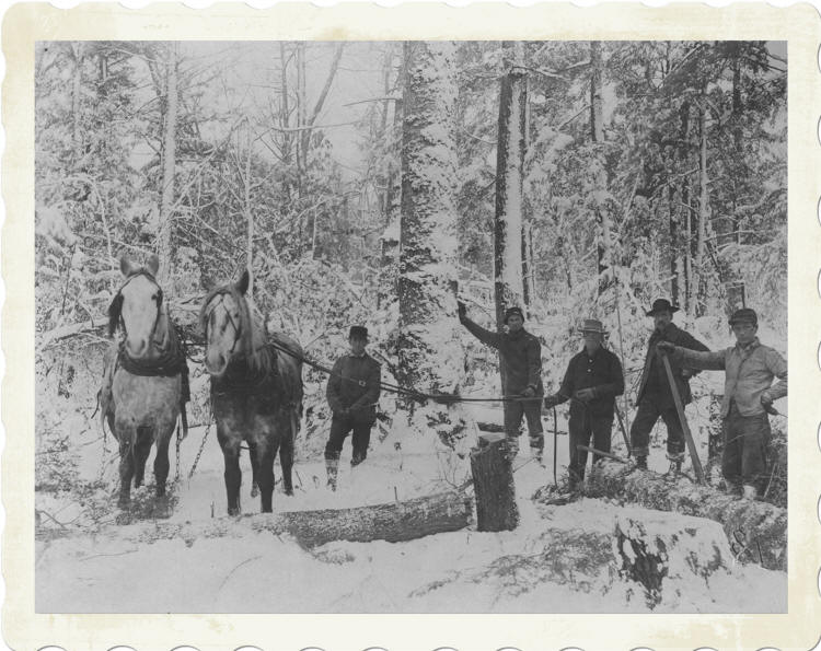
Logging in the old way required dragging, or snaking out a log at a time. One or two horses were needed for the operation, to get the logs to a loading area.
¤¤¤¤¤¤¤¤¤¤¤
|
© Every submission is protected by the Digital Millennium Copyright Act of 1998.
Show your appreciation of this freely provided information by not copying it to any other site without our permission.
Become a Clark County History Buff
|
|
A site created and
maintained by the Clark County History Buffs
Webmasters: Leon Konieczny, Tanya Paschke, Janet & Stan Schwarze, James W. Sternitzky,
|