|
|
|
Clark County Press, Neillsville, WI April 16, 1997, Page 25 Transcribed by Dolores (Mohr) Kenyon. Index of "Oldies" Articles |
|
|
|
Clark County Press, Neillsville, WI April 16, 1997, Page 25 Transcribed by Dolores (Mohr) Kenyon. Index of "Oldies" Articles |
Good Old Days
By Dee Zimmerman
Clark County’s Early Years of Transportation
The earliest settlers used the waterways as routes of travel, bringing their supplies from Mississippi River points or from Black River Falls in scows. The Black River served as the main waterway into a new territory covered with a wealth of white pine and hardwoods, attracting the lumbermen. Later trails of the crudest kind were cut through the woods.
The first regularly established road into the county was one from Stevens Point to Weston’s Rapids, authorized by the provisions of Chapter 50, Private and Local Laws for the year 1853. The road was duly surveyed and plotted by Aelic Martin, a surveyor, and the survey and plat deposited with the Secretary of State. It appears that there was some in-formality in the papers and by chapter 293, of the Private and Local laws of 1857, the survey and plat previously filed was declared by the legislature to be the legal and lawful survey of the state road.
It was quite common in the early days to obtain the legislative authority to survey and locate state roads; thus in 1857, James O’Neill, Sr., Robert Nelson, and G. S. McCormick were appointed commissioners to establish a state road from Neillsville, by way of Sumner post office in Trempealeau County to Abner in Buffalo County; and the same year Harris Searls, Garwood Green, and Melvin Ferris were appointed commissioners to lay out a state road from Weston’s Rapids (two miles north of Neillsville), westerly through the counties of Clark, Jackson, Eau Claire, Trempealeau and Buffalo to Alma on the Mississippi River.
In all of those old acts, there is found the stipulation that no part of the expense of laying out the road should be borne by the state.
Efforts to obtain mail facilities were among twenty-three different memorials to Congress in 1857. The first, No. 1, was a memorial representing “that the interests and convenience of a large number of inhabitants of the northern and eastern part of a mail route by land from Stevens Point in Portage County via Weston’s Rapids in Clark County to St. Paul on the Mississippi River. Until post offices were established at Weston’s Rapids and Neillsville, the residents of the county generally obtained their mail from the post office at Black River Falls in Jackson County.
During the Civil War, there were no roads worthy of the name in Clark County, and the “Tote” roads leading to the lumber camps were usually in better condition than the public roads. People usually went about through the woods, and oxen were still the principal beasts of burden.
A few crude bridges were built across the rivers and creeks. But, at some of the principal crossings, the only way of getting across was on the rafts and booms. County bridge building was started in 1857, when a bridge was built across Weston’s Rapids, and the county board appropriated $1,000 for bridges across Cawley Creek, Rock Creek and Popple River. Various appropriations for small bridges were made in succeeding years. July 4, 1864, the county board authorized Millet J. Smith to maintain a ferry across the Black River in Section 25, 23 North, Range 3 West (Town of Dewhurst). The next bridge built across Black River was constructed in 1866, about six miles south of Neillsville, $3,000 in tax certificates being contributed for the purpose. In the same year, $667 was appropriated for a bridge across Wedges Creek in the Town of Levis.
Even as late as 1868, there were no good roads in the county. State roads had been surveyed from Weston’s Rapids to Stevens Point, from Neillsville to Buffalo County by two different routes and a few towns had improved turnpike roads here and there, mostly through the medium of citizens working out their tax debts. But the result of such crude work was that often after a rainfall the surveyed turnpike was in worse condition than the virgin soil.
In 1868, James O’Neill, Sr., then a member of the assembly, secured the passage of Chapter 483, Local Laws of 1868, through which the good roads movement in the county received its initial momentum. This act empowered the county board to levy a tax up to the amount of $30,000, to be expended along the main Black River running north and south through the county. An excellent procedure was provided for, by which the route was to be considered in two-mile sections. On May 25, 1868, the board, under this act, levied a tax of $7,000, and appointed Benjamin F. French, James Hewett and Jones Tompkins as commissioners to carry out its provisions. Within three years, the entire $30,000 had been expended.
In 1871, a similar act was passed through the efforts of George W. King, for the construction of a road from Neillsville to Humbird, the amount authorized being $5,000. King then had a sawmill at King’s Mills, five mile east of Humbird, and desired a good road to his place connecting with the Black River Road. Much of the money was expended in building a corduroy road between Hewettville and Humbird, the type of soil making it necessary.
For the next four decades, the roads continued to be in a deplorable condition. The county was becoming more settled, thoroughfares were being extended here and there throughout the county, and money was being spent for their construction, and maintenance. But there was no general system and there was not comprehensive study of the problems involved. So each spring found the roads between the villages absolutely impassable.
The towns were divided into road districts with a path master appointed by the town board, and the result was a patchwork system, depending for its results almost entirely on the ability of the individual path master.
Under the laws of 1907 the county board, that fall, prepared a prospective system into a system of county highways. The system was amended in the fall of 1911, and was adopted as organizing the county into a prospective State Aid Highway System, under the laws of that year. W. C. Thoma was, on Nov. 18, 1911, appointed county highway commissioner. In 1912 and 1913, only grading and surfacing, and the building of culverts were undertaken, the surfacing work being started in 1915. However, there was as yet no comprehensive plan of procedure. Much of the work was done in little parcels, here and there, unconnected with any other strip of improved road, and for the most part benefiting primarily those who had enough influence to get the work located where it would improve their own property.
In the fall of 1916, there came another change when the county board adopted a County Trunk Line system, for 150 miles of the County System of Prospective State Highways.
“Trunk Line No. 1: known as the Neillsville-Withee road; beginning at the county line on south, thence north through Neillsville to the north county line, containing forty-seven miles. Trunk Line No. 2: known as the Stanley-Abbottsford road, beginning one mile west, county line, thence east and south to Unity and beginning one mile west of Abbottsford, north to county line, containing forty-one miles. Trunk Line No. 3: known as the Greenwood-Spencer, beginning one and one-half mile south of the southern boundary, city of Greenwood, running due east five miles, north half mile, thence east to Spencer, containing fourteen and one-half miles. Trunk Line No. 4: known as the Humbird-Marshfield road, beginning at western boundary line of county, thence east and north to Marshfield containing thirty-four and one-half miles. Trunk Line No. 5: known as the Neillsville-Pittsville road, beginning at Neillsville, thence south and east to Pittsville, containing eighteen miles.”
The board also provided that all the new work undertaken must be along the main routes until all villages in the county would be connected with each other. Applications were made for federal aid, a system with two trunk lines to cross the county. One would enter northwest of Humbird and extend eastwardly, passing through Neillsville and Granton, on the way to Marshfield (now Hwy. 10). The other would enter the county east of Stanley, and cross in due easterly direction to Abbottsford (now Hwy 29).
Clark County was the first to adopt the patrol plan of road care on county trunk lines. The system provided state aid roads would be divided into eleven sections of six to eight miles each, and the country trunk line roads into sections of from seven to sixteen mile each. Each section would have a patrolman assigned to keep it in repair and with constant care, also to assist travelers by giving directions or rendering aid if necessary.
(This article was originally written in 1918)
It is interesting to note how some of our present day road routes were derived from the pioneer wagon trails or lumbermen “tote” roads.
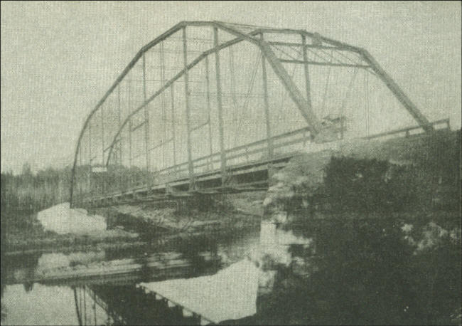 |
The over-head truss steel bridges were commonly seen spanning the rivers and creeks of Clark County at the turn of the century. (Photo courtesy of Clark County Historical Society’s Jail Museum)
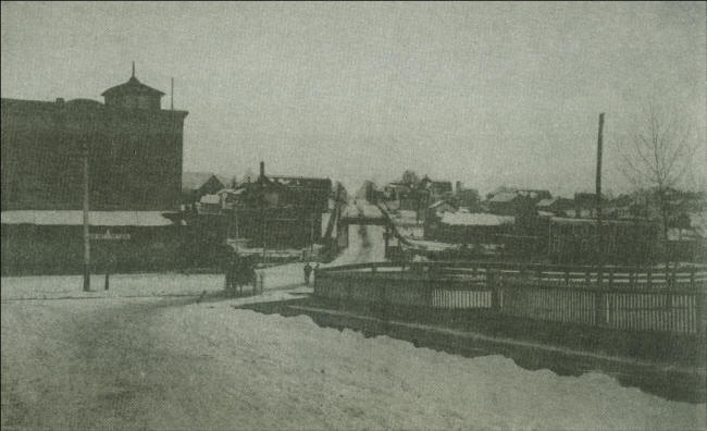 |
A late 1800’s view of Hewett Street, also one of the county’s first roads; on the left is the Grist Mill, and the Ghent-Korman building on the right. The ornate steel bridge over O’Neill Creek centers the scene.
|
© Every submission is protected by the Digital Millennium Copyright Act of 1998.
Show your appreciation of this freely provided information by not copying it to any other site without our permission.
Become a Clark County History Buff
|
|
A site created and
maintained by the Clark County History Buffs
Webmasters: Leon Konieczny, Tanya Paschke, Janet & Stan Schwarze, James W. Sternitzky,
|