Bio: Storrow, Samuel Mary Appleton
(1787 - 1837)
Contact: Stan
----Source: Wisconsin Historical Society Collections, Volume VI (1872)
Surnames: Appleton Baker Bell Breck Brown Carter Champe Giillam Clark Higginson Jennings LaSalle McNeill Ouisconsin Pierce Storer Storrow Taylor Tomay To-Mah Volney Wentworth
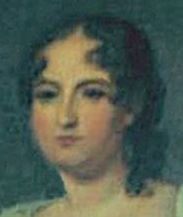
Samuel Mary Appleton Storrow
Birthdate: September 05, 1787
Birthplace: Campobello, New Brunswick, Canada
Death: January 13, 1837 (49 yrs. old)
Farley, Brandy Station, Culpeper, Virginia
Family
Son of Thomas Storrow and Anne Appleton
Wife: Elizabeth Hill Farley Storrow.
Father of William Farley Storrow; Maria Champe Bell; Mary Appleton Storrow;
Samuel Appleton Storrow; Elizabeth Carter Storrow and 1 other.
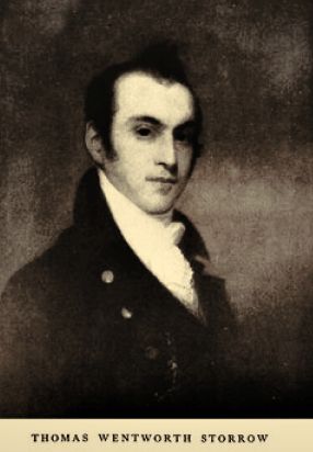
Brother: Thomas Wentworth Storrow
(1779-1862); Louisa Wentworth Higginson and Anne Storrow
Thomas Wentworth Storrow was born in London on 1 September 1779 to Thomas
Storrow (1751-1794) and Ann Appleton Storrow (d. 1796). His siblings were Ann
Gillam Storrow (1784-1862), Louisa (Storrow) Higginson (1786-1864), Samuel Mary
Appleton Storrow (1789-1837), and Rebecca Susannah Storrow (1790-1795). Thomas
Storrow was a British Army officer engaged in trading ventures at Campobello and
Kingston, Jamaica. The family relocated to Boston after Thomas's death in 1794,
which was followed shortly by Rebecca in 1795, and Ann Appleton in 1796.
Having left school at age thirteen when his father died, at fifteen Thomas
Wentworth went to work at Luke Baker's store in Cornhill, Boston. Stephen
Higginson (d. 1834) later set him up in business as a trader or commission
merchant, in partnership with Edward Breck and John C. Brown. When Breck later
left the firm, the business became Storrow and Brown. On 4 October 1804, Thomas
Wentworth married one of John C. Brown's cousins, Sally Phipps Brown
(1783-1837). Thomas Wentworth and Sally had five children: Thomas Wentworth, Jr.
(1805-1861), Susan Clark (Storrow) van Wart (1807-1843), Charles Storer Storrow
(1809-1904) (see below), Ann Louisa Storrow (1816-1842), and Samuel Appleton
Storrow (1813-1842).
**********************
Samuel Mary Appleton Storrow attended Harvard University from 1804 to 1807, and served as a judge advocate o the U. S. Army, 1816-1820, in Washington, D.C. He was assigned by Major General Jacob Jennings Brown, the ranking general officer of the Army, to examine posts on the western frontier during the fall of 1817. Storrow journeyed from Detroit to Green Bay across the Great Lakes, and then overland through Wisconsin to Chicago, Fort Wayne, and Detroit. His report on the trip, published as a pamphlet the following year, is now extremely rare (only 5 copies are known). It includes unique descriptions of Green Bay, Wisconsin Indian villages, and the topography of the lakeshore region.
of Samuel a Storrow the author of this narrative we only know that he was a
native of Massachusetts and acting judge advocate in the army in 1815; judge
advocate in 1816; and resigned Feb. 5, 1820 this narrative was published in
pamphlet form 39 octavo pages; the Wisconsin State Historical Society's copy is
without title page if it ever had any and we can find no reference to it any of
the catalogues of the principal American libraries.
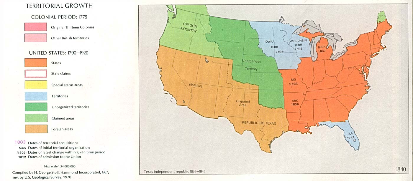
1817 Northwest Territory Expedition--Detroit to Green Bay,
Samuel Storrow's Letter to his superior:
1785 - 1820 United States Map; 1840 USA Map
1st December 1817 to Major General Brown,
My Dear Sir: — I beg leave to submit to you a detail of such occurrences subsequent to my departure from you as have not already been presented in a different shape. Whatever relates to the tour is due to yourself as your request was the cause of it.
At midnight of the day when I took leave of you at Detroit, August 17th 1817, I embarked in a barge to proceed by the river and Lake St. Clair to fort Gratiot. The country bordering the two waters I found level and fertile. It is scantily peopled by French Canadians, who reside on the margin, and make no improvements in the interior. The small surplus of their produce is purchased by vessels coasting between the lakes. In the rear of the settlements is a growth of substantial timber, and an abundant supply of natural grass. At the upper parts of the river the soil meliorates; the banks are high and often picturesque. On the evening of the 19th, I reached Lake Huron and Fort Gratiot.
Without recurrence to the map, a stranger is led into error from the different names given to the same water. Since leaving Detroit I had been on one stream, known in its various parts as Detroit river, Lake St. Clair the river St. Clair, and the river Huron. Fort Gratiot is situated on the right bank of the latter, which is the rapid formed by lake Huron in its first outlet to the waters below. Its direction is from north to south, its width about 800 yards, its length a mile and the rapidity of the current nearly five miles an hour. With port Gratiot itself you are already acquainted the site of it is within three hundred yards of the lake on a slight eminence about 150 yards distant from the water's edge; so that the guns of a well constructed work may command the strait and its opposite bank which for more than the range of common shot is elevated but a few fest above the water.
Considering the river Huron as the natural avenue from the upper to the lower lakes, it is surprising that no efforts were made to insure the command of it previously to the year 1814. To ourselves under the existing mode of communicating with the north-western frontier it affords the only means of commercial or military conveyance. To the British, it serves for the former, although for the latter they have found an expensive substitute in the land and water carriage from York to their naval depot on lake Huron. The position is less important towards any white neighbor than towards the Indians. To them it is the only thoroughfare. The possession of it engenders new dependence during peace, and might become a most important barrier against invasion. The intervention of a for tress between an Indian and his home is an insuperable obstacle to distant warfare. Had the pass been defended in 1812, few would have gone beyond it to the siege of Detroit.
Within the range of the guns of the fort there is a fishery, which for years, perhaps ages, has given sustenance to the tribes inhabiting the lower parts of lake Huron. From this and other causes they have ascribed to it a moral value even beyond its due, and rarely pass without making it, as much from superstition as convenience, a resting place on their way below.
Fort Gratiot commands an interesting, but limited view of the lake, on both sides of which the shores are low, as far as the eye can extend. In the immediate vicinity the soil is in different, although not bad; on the British side it is inferior, and seems an alluvial deposit of sand, It bears marks of having gradually advanced on the water; is loose and barren and for three or four miles towards the interior not different from that of the margin the country wherever it can be essayed is secondary like the region of which it is a part the pebbles lining the beach are in equal proportions secondary and primitive small pieces of silex quartz and detached morsels of granite being found in the same quantity with secondary limestone there are no large rocks on the shore or near it on reaching lake Huron I felt a renewal of the mortification which I expressed to you on leaving Sackett's harbor; I mean the portable barometer, with which I had intended to have taken the altitude of the upper lakes, but which was broken at the commencement of our tour.
On the 22d, (August,) I embarked from Fort Gratiot in a small vessel for Michilimackinac; but, after an uncomfortable absence of twenty-fours (hours?), was forced back into the strait by one of the severe tempests for which this lake is remarkable. On the 25th, we embarked under better auspices; at mid-day of the 26th, found ourselves off Point au Bargue, at sunset off Point au Sable, the eastern and western capes of Saguina bay. This immense bay commences near the center of Michigan, in a river of the same name and after passing a fertile country occupied by the Saguinas and Chippewas empties itself from the south-west into lake Huron. Its width at the mouth is thirty miles (Fr. Hennepin calls it twenty leagues!). It generally carries with its current a wind and sea which disturb the lake for some distance at midnight of the same day we passed thunder bay and the islands of the same name which they derive from the incessant storms which prevail in their neighborhood on the morning of the 27th, found ourselves near to Presque Isle; at evening caught sight of the island of Bois Blanc, and on the morning of the 28th, anchored, after a rapid passage, at Michilimackinac.
The first view of this interesting island justified the expectation it had excited. Its picturesque situation, abrupt eminences, and military facilities, resemble some rare effort of the pencil where fancy and fact are blended. After passing the beach, which is lined with Indian wigwams, you enter a contemptible village of forty or fifty houses, filled with a squalid, mixed race of Indians and Canadians. The ground is level for the space of one hundred and sixty yards, when there rises an abrupt eminence of one hundred and twenty five feet, which extends irregularly from the east nearly to the west of the island. This elevation is ascended diagonally, and on the summit is planted Fort Mackinac, which seems to impend over the village below. In the rear of this height rises another, which from the suddenness of the first cannot be seen from the village on leaving Fort Mackinac to ascend it the ground is at first gradually inclined at the distance of five hundred yards it becomes precipitous and after a perpendicular of one hundred and fifty feet in one hundred and thirteen yards distance ends in a summit on which is planted Fort Holmes — making the distance between Fort Holmes and Mackinac six hundred and thirty yards, and the elevation of the former over the latter one hundred and eighty-six feet nine inches. No scenery can be more sublime than that exhibited within the range of this eminence. The harbour of the island faces the south eastwardly. In front of it lie Round Island and Bois Blanc; in the rear of these islands, and extending towards the west appears the main land of the Michigan territory, terminating in old Mackinac, which projects into the lake from the southwest. Opposite to old Mackinac lies point St. Ignace; between which two projections is the confluence of lakes Michigan and Huron. On the northwest stretches the main land of the Illinois territory, extending in beautiful undulations towards the northward, and, in the north itself the many islands of Lake Huron. This archipelago, the distant main land, and the expanse of the two lakes, form one of the most imposing spectacles I have ever witnessed.
The island of Michilimackinac is from twenty-two to twenty-five miles in circumference (Lat. 45 deg., 54 min., 15 sec., observation taken by Major Gratiot and myself). Except in the north its banks are precipitous leaving Fort Holmes, the ground, which is uneven with frequent abrupt eminences, is intersected by numerous small winding paths, overshadowed by alders, birch, and pines, which form a natural arbor in every direction. On the eastern side, I found one of the most interesting natural curiosities I have ever witnessed. On the edge of the island, where as elsewhere, the banks are perpendicular, you creep cautiously toward the margin, expecting to overlook a precipice; instead of which you find a cavity of about 75 degrees descent, hollowed from the direct line of the banks; and across it on the edge of the precipice connecting above the parts which the excavation has divided below an immense and perfect arch. Its height is 140 feet from the water, which is seen through it. It is supported midway of this eminence by a sort of natural abutment, above which it is elevated about 50 feet, with a sweep of 45 feet. Looking from the interior, the excavation resembles a crater; but, instead of an opposite side, presents an opening, which is surmounted by this magnificent arch. Passing under it, which is done with some difficulty and danger, you find the foundation of the right arm to rest on another arch, of an elevation of about five feet, through which you are led in a different direction in an inclination of about 60 degrees. Having passed it, you find yourself two thirds of the way down the precipice, and accomplish the rest by fastening to the shrubbery and projecting rocks which are about you. When on the beach below, you see this mighty arch 140 feet above you, half hid in trees, and seemingly suspended in the air. It may be accounted for, in the more rapid decomposition of the lower than of the upper parts of the bank. A rocky substance above, resting on one less solid below, remains entire and supported by the coherence of its own parts, not withstanding the dilapidation of its basis. From the lake it appears like a work of art, and might give birth to a thousand wild and fanciful conjectures. Had the region been known in fabulous times, it would not have been without its name in history. The caprice of nature would have been ascribed to the agency of giants or demigods, and perhaps transmitted to posterity as the final relic of some temple dedicated to the colossal genius of the island.
The bed of Michilimackinac is of limestone on which there seems to have been the action of no acid except the carbonic it is secondary but upon the surface are found numerous masses of primitive foundation such as granite gniess horn blend and silex. The beach is lined with pebbles of secondary limestone. From the formation and shape of the islands, there are indications that its surface has been formed at different periods by the recession of the lake. Fort Holmes and the sugar loaf rock (a conical rock of that name) would seem to be the first parts that had emerged; the high ridge, on which is planted Fort Mackinac, and which nearly encircles the island, the second; the low shores of the north, and the plain about the harbor on the south side, the third.
If Michilimackinac commanded any pass, the position would be invaluable, for it may be made impregnable. The small bay and south side are overlooked and defended by Fort Mackinac, which fort is overawed by Fort Holmes. The east, and a greater part of the west sides, are impracticable of ascent. The shores of the north are lower and the only parts where a lodgment could be effected. But even were the foot hold gained, the winding paths, abrupt eminences, and tangled under-growth would preclude an advance beyond it. With such advantages of ground, a weak garrison could cripple any assailing force before it could reach Fort Holmes, which position might be the citadel as well as the summit of the island. The eminence rises like a mound, and is unassailable except on one side, which being narrow, might be fortified by art. The possession of this spot enabled the British to accomplish the ruse, which gave them the island in 1812; yet, important as it is, it was neglected by the French, the English, and ourselves, until fortified by the English in 1813 with a block house, surrounded by a fraise and ditch. Old Mackinac scarcely deserves the name of a fortification, being merely a platform enclosed within palisades. There are four block houses; the two towards Fort Holmes, intended as bastions, being entirely useless.
I have already expressed to you my obligations to Col. McNeil of the 5th infantry, for daily acts of kindness during my stay within his command; being now about to leave it for Lake Superior, he furnished me with a boat manned by five soldiers, and increased the favour by giving me as a companion Lieut. Pierce, of the artillery.
I embarked on the 1st of September. At the distance of 12 miles from Michilimackinac, we entered a cluster of islands on the west of the lake; among which (pursuing our course north, a little eastwardly) we remained during the day, and encamped on one of them at night. At about mid day of the 2d, we entered the Detour, (the bay of which St. Mary's river is the head). Passing the southern-most cape, and leaving Drummond's island on the right, we commenced a westwardly direction, and towards evening arrived at the beautiful but deserted island of St. Joseph's. We continued coasting on the south side of this island, passing many others on our left, until late at night, when we encamped; and the next morning pursued the same course, having left St. Joseph's behind us. In the afternoon of the same day we reached a short but very swift rapid, running among a group of small islets, making a sort of miniature archipelago; immediately on passing which we entered the St. Mary's. After being encircled with islands, the view of this bold and noble river has a most imposing effect. It is about a mile and a half in width, and perfectly straight for the distance of two miles, at the end of which you see the Falls of St. Mary, like a bridge of foam directly across it. In the vicinity of the falls there is an establishment of the North-West Fur Company, and a number of individuals engaged in the same traffic.
After being hospitably entertained by a gentleman residing on the English side of the river. I embarked in a birch canoe, manned with Canadian voyageurs for lake superior. After passing the portage of the Falls, we re-embarked, and in a few hours, reached Point au Chene, on the British side, where the lake commences; from which spot I took my first view of it, and that not without feelings of emotion. The wind being high, it was impossible to proceed further in the canoe, which I left and walked about four miles; when I saw on my right, on the north side, about a league distant, Point Gros Cap, and at a greater distance, on the south side, Point aux Iroquois — both high projecting promontories, which would seem, at some former period, to have formed one connected ridge, through which the lake has since forced its way. The shores about me were low and barren, being merely an allusion of sand; a few leagues distant they became higher. As the wind precluded the use of the canoe, and a swamp being before me, I was obliged to content myself with this limited view, and, after an unavailing attempt to reach Gros Cap, reluctantly retraced my steps.
From the lake to the edge of the falls our passage was swift, the current rapidly increasing as we advanced, We performed the descent (for which we previously prepared ourselves) in four and a half minutes, from the upper to the lower edge, a distance of nine hundred yards, the fall being twenty two feet ten inches. Neither the fall nor the rapidity of descending it are remarkable; the danger and interest are excited by the eddies, the adroitness of the boatmen, and the number of rocks that make the adroitness indispensable. In the spring, when the waters are high, vessels of eighty or one hundred tons pass down on being lightened. The width of the river is a mile and an eighth; the passage is on the American side.
I was not a little mortified in being impeded in my attempts to reach Gros Cap, or some other high shore of Lake Superior, as from, indications about me, I was induced to expect the means of interesting speculation in mineralogy. On entering the Detour, I found the earthy substances to be all of secondary limestone, on the loosest and most recent formation. When within a few leagues of the Falls, I observed this body to change and give place to a compact sandstone, such as is known by the name of old red sandstone; of this the bed of the Falls was composed, as well as the region about it. Upon the surface were scattered masses of primitive formation to a greater extent than I had witnessed before, and all deeply oxidated with iron. There were many pebbles of silex, and more of iron pyrites. I had likewise heard that the beds of Gros Cap and Point aux Iroquois, and the line at the bottom of the lake between these two points, were formed of a singular composition, which, from description, I supposed to be gray wacke. These several appearances induced a belief that the geological character of the country was about changing; that after leaving a secondary region, as the Falls and parts below, passing a transition, (if my conjectures were correct,) as Gros Cap, I might be led to one of primitive formation above. It would have been important to ascertain the correctness of this conjecture for the sake of the fact itself, but more especially as the confirmation of it might have led to the discovery of metallic productions, such as are ordinarily found under similar associations.
I procured, and have shown to you, a specimen of the copper ore of this region, but could obtain no sufficiently satisfactory information relative to it. It is found in the fissures of a rock or rocks, and in equal purity to the samples you have seen; so that it is cleft from its bed by the natives with tomahawks. The bed is two hundred miles distant from the outlet of the Lake. Important as this subject is, my information respecting it is too indistinct to warrant a farther account.
Few or none of the Indians of lake superior came from it during the late war; but as our settlements are advancing towards their retreat, they may not be equally backward at a future period. A military position at the Falls, by commanding the avenue which leads from one lake to the other might obviate the danger of an inroad before it commenced. Michilimackinac, notwithstanding its strength, is of no intrinsic utility. Its importance is relative, being derived from the garrison, the Indian agency and custom-house. Were these removed to Lake Superior, the effect would be the same on the natives who have heretofore frequented that island, while the defenses of the frontier would be made more perfect, and the tribes of the Upper Lake overawed by the occupancy of their only outlet. On the American side there is, as I have already mentioned, an elevation suitable for the site of a fort. There is none on the opposite bank.
About midnight on the 5th, I embarked to return to Michilimackinac. At 3 o'clock P.M. of the 6th, reached the neighborhood of the Detour and landed on Drummond's island, in order to look at the British post at that place. In landing on the south side I was surprised at what I took to be a recession of the lake. For the first hundred and fifty yards, the ground is gently elevated, and the earthy productions bear the same character and appearance as those at the bottom of the Lake, large round masses of secondary limestone; on reaching the summit, they change to a congregation of small pebbles of different sorts, rounded by the action of the water, and arranged in the same manner as on the beach; the whole giving every indication of having once been the immediate margin of the water. Should this be the case, the descent of the Lake must have been one hundred feet from its former elevation.
This island is garrisoned by a single company, and has no advantages except that of a small and secure harbor. I encamped on the night of the 6th, on an island of the Lake, and, on the evening of the 7th, arrived at Michilimackinac; having experienced more than once how dangerous and treacherous is the navigation of Lake Huron, in the manner in which I at tempted it.
After a day or two spent in Michilimackinac I embarked for Green Bay, in an open boat manned with soldiers, a guide and interpreter and happily my former companion Mr. Pierce we reached point St. Ignace, leaving old Mackinac on our left, and rowed westwardly along the north shore of Lake Michigan, having the expanse of the Lake open to us on the south. We traced this course until ten o'clock at night; when on leaving to encamp, I was surprised at the singular and capricious forms which the storms of the Lake had given to the sand on the beach. For the distance of half a mile it was thrown into mounds of every shape, angular and conical acclivities, abrupt ascents and descents of the wildest and most grotesque appearance. These singular varieties, our tents, fires and the soldiers carrying baggage, gave the scenery an air rather of Africa than of America, and likened ourselves to some tribe wandering on the sands.
For the succeeding days, the 11th, 12th, 13th and 14th, we pursued the same course, the passage being marked with no peculiar incidents. At times I walked a distance on and about the beach; at other times the wind or surf obliged us to remain encamped. The country was marked by no peculiarities; it was generally rocky and barren, a character that would be natural to the margin of the Lake. The bed of the country is secondary limestone, on which the soil is thin. We occasionally met natives, and on all parts of the beach the tracks of wild animals particularly bears. Our course led us past the river Manastie, (so called from its abundance of fish,) and several other streams of inconsiderable importance. We likewise passed several projections of land, known by the names given by the voyageurs of Point la Carpe, Point de Patterson, Point Schouchoir, Point aux Ecorces, and others; until on the 15th, we reached Point Detour; at which point commences the chain of islands which extend across that arm of Lake Michigan called Green Bay, and connect with the western extremity of the main land of that Lake. Our course now lay across this traverse, a navigation hazardous to an open boat, as it leads into the broad Lake, and often to a distance from land.
Leaving Point Detour directly in our rear, and a large body of water, called Baie des Noquets, behind us on the right, we assumed a southwardly direction, in order to gain the opposite cape of Green Bay called Cap Port des Morts. The course lay among islands. The first seven miles distant from the main, contained a large Indian village. We passed it, and entered a cluster in which some bore the marks of fertility; others were merely sand banks. Among this group there was one of singular beauty. It rose perpendicularly from the water to an elevation of seventy feet, and was composed of secondary limestone, smooth and regularly stratified, so as to give it the appearance of the facade of some stately edifice. On the summit it bore a growth of timber, the trees growing on the very margin, so as to continue the perpendicular of the sides. On the upper as well as lower parts, it bore evident marks of the attrition of water. On the night of the 15th, we encamped on an island, and on the morning of the 16th, made our way to another. While upon it we were met by a small party of Indians, one of whom our interpreter recognized to be Cecoton, or, The Spring deer, an Ottawa warrior of a fierce and turbulent character. He pointed to an island, which, he said was the haunt of his tribe and family, whither we proceeded. It was the most beautiful of the group, and known to the voyageurs by the name of the Isle de Petit Detroit, from its facing a small strait formed by itself and another island which nearly encircles it. The grounds where we first landed bore the marks of recent cultivation, but were uninhabited.
Following a winding path, we reached a cemetery, decorated after the rude manner o the natives, with flags and paint; each grave being sheltered by a mound of bark, containing an aperture for the deceased to breathe through, and in front the remnants of food and embers. The pathways led us through many beautiful but deserted fields, where the industry of the Indians had mellowed the wildness of their island, and formed a scene apparently too tranquil for a turbulent spirit like that of Cecoton. Finding no one abroad, we discharged our muskets to attract some of the islanders; the sound was answered by the barking of a dog, and soon afterward we encountered a man, armed, and apparently acting as sentinel. He told the interpreter that the people were on the skirts of a forest at a distance, where they cultivated the fields. We followed him, and were led into a large and wretchedly tilled cornfield, in the midst of which were a number of cabins. Among the many interesting objects which this strange community presented, was an old chief of not less than ninety years of age, who had been a warrior from his youth. He was naked, like those about him, and by no means deficient in strength and agility.
Leaving this beautiful island, we reached, on the 16th, the southerly cape of Green Bay, Port des Morts, so called from the destruction at that place of a number of the Pottawatomies. The cape itself is high and perpendicular. We encamped under the precipice on a small margin, the water washing the foot of our tent. On the morning of the 17th, we commenced our course westwardly along the shore, stopping at several islands, one of which contained a small miniature harbor, and the marks of Indian cultivation. The cabins were deserted, but on exploring the island we found the dead body of a man extended on a scaffold, after the manner of the Chippewa's. Implements of the chase were at his side, and at the foot of the scaffold, the remnants of a deer.
Throughout the 17th and 18th, we continued our course, and reached, on the night of the latter day, Cape Winnebago, having passed the Baie des Eturgeons the Vermillion islands and the River Rouge. From the bottom of the Baie des Eturgeons there is a portage of but two miles to lake Michigan.
We were now, as we had been since the 16th, in Green Bay, which is the grand channel of communication between the Mississippi and the Lakes, and is a body of water on the same noble scale as the Delaware or Chesapeake. It takes its rise and principal source in the Fox river (Outagamis,) which nearly unites with the Ouisconsin, which latter runs in an opposite direction, and is one of the most important tributary streams of the Mississippi. At its head this bay receives the Fox, Duck and Devil rivers. On the northern side is the Monomonee or Wild Rice river a stream which takes its source near lake superior, and is a mile and a half in width at its mouth. On the same side, near the outlet, is the Bay des Noquets, and on the south the Bay des Eturgeons and River Rouge, just mentioned. from the head (the Fox river) to the opening into lake Michigan the distance is ninety miles; and across the opening which is guarded by the chain of islands I have mentioned, the width is thirty miles. These islands, excepting the few which are merely of sand, are lofty and gene rally precipitous. Their formation is exclusively secondary limestone. The eastern parts of the south side of the Bay are of the same structure and composition until reaching the Sturgeon Bay; when the banks become lower, the soil meliorates and produces a growth of white and red oak, sugar maple and pine.
On the 19th we arrived at a wretched and half starved village of Ottawa's; in the afternoon of the same day we reached the Fox river, and three-fourths of a mile from the mouth of it the fort of Green Bay where I was kindly received and spent several days.
The site and structure of this work I have already explained to you. At no part of the Indian frontier could a fortress be more useful or indispensable. It is in the chain of connection with the Indian settlements between the Mississippi and the Lakes. It opens a way to their retreats in the west, and commands their thoroughfare towards the east. the Fals Avoines, Ottawas, Pottawatomies and dangerous Winnebago's consider this place as their accustomed and privileged haunt. In times of peace they sometimes assemble about it to the number of one or two thousand; but for hostile purposes might collect twice that number on the most sudden emergency. The importance of the position was apparent in the jealousy with which the nations regarded the occupancy of it. They considered it as a check to their predatory habits, and assembled in a body to oppose it; being overawed at that moment, they have since threatened that the first reduction of numbers at the post, that they shall make it their own.
The inadequacy of a single garrison to repress so great a number of malcontents, would naturally lead to the means of rendering this important position capable of its own defense. A small compact community of whites might easily effect it. If at the late disbandment of the army, the Indian title to a few thousand acres on the banks of this river had been extinguished and conferred, as bounty lands, on certain select soldiers, who would have pledged themselves to become actual settlers; the contiguity of their farms, their coherence for common protection, and a fort to resort to. on emergency, would, if it did not modify the Indian character, at least have formed a cheap and permanent barrier against encroachment, No other inducement would have been required to form such a colony than the continuance of rations for a single year after disbandment.
The position of the fort is, as I have already mentioned, on the left bank of the river, the same with that of the former French and English works. Below the fort, towards the bay, is an extensive prairie bordering the river, on the banks of which there is a growth of wild rice; above it there is a meager settlement of French Canadians intermingled with the natives. During the late war this unhappy colony experienced every misery to which its contiguity to the savages could subject it. Most of the inhabitants enrolled themselves with the Indian warriors, and came to the field with them; from the guilt of which they may be exonerated, from which their defenceless situation, and the destruction which would have been the consequence of a refusal. In conversing with this outcast people, I was surprised at their devotion to the land of their fathers, although the memory of no man living reaches to the period of the connection. The lapse of half a century, which has made them the property of two different governments, affords nothing to obliterate their traditionary remembrance of France, their primitive country. Their livelihoods are derived from the fur trade; but, notwithstanding the cold of their winter, they might be supported by agriculture. The ice leaves the river at the close of March, and the fields may be tilled in May. The soil is above mediocrity, and congenial to the growth of vegetables and wheat; the summer is too short for corn. The prairies afford sustenance for any quantity of cattle.
While at Green Bay I made observations on the ebb and flow of a lake tide. The existence of this phenomenon has been known for nearly a century and a half, and yet has occasioned no thought nor investigation. Even Volney has al lowed it to pass without a theory! At 11 o'clock A.M., I placed a stick perpendicularly in the water; at half past nine, P.M. the water had risen five inches; at 8, the next morning, it had fallen seven inches; at 8 of, same evening, it had risen eight inches. During this period the wind was in the same direction, blowing gently against the flow of the tide.
After a short stay at Green Bay I made arrangements with a Fals Avoine chief to conduct me as a guide to the Winnebago Lake; from whence it was my determination to proceed on foot through the wilderness, to Chicago. At midday of the 22d of September, I took leave of Maj. Taylor and the officers of the 3d Regiment, who had most kindly entertained me. I likewise took a reluctant leave of my excellent companion, Mr. Pierce. For the residue of the day my course lay on the left bank of the river, through good lands and a growth of oak. I passed two springs strongly impregnated with sulphur, and at night stopped at a rapid of the river called Kakalin, being the last house and the last whites I expected to see for the distance of 250 miles.
On the 23d I entered the wilderness, attended by my Indian guide and a soldier of the 3d Regiment, who led a pack-horse loaded with provisions and presents for the natives. We forded the Fox river, and losing sight of it, proceeded in a westwardly direction; at first through a small Indian path, and, on that failing us, through a wilderness entirely trackless.
The journey of this day was painful and uninteresting. The thickness of the forest rendered marching difficult, and almost entirely impeded the horse; but for exertions in assisting him over crags, and cutting away branches and saplings with our tomahawks, we should have been obliged to abandon him. The land was broken with hillocks and masses of rock. The growth of timber indicated a cold soil, notwithstanding which we occasionally saw the sugar maple. At night we lay on the ground. On the morning of the 24th, we resumed our march, extremely chilled. The thickness of the forest prevented the rays of the sun from coming to the earth, and during the previous night the guide had obliged us to keep small fires from fear of the Winnebagos, who were about us, and from whom there is always cause for apprehension.
After a toilsome march of eight or nine hours, we arrived abruptly at the shores of a circular lake, which I found to be Lake Winnebago. I never experienced a more grateful transition than from the damp and tangled wood to the sunny margin of this beautiful water. It is nearly round, and apparently about sixty miles in circumference. For a short time we walked upon the beach; but finding it too narrow, were again obliged to resort to our uncomfortable way through the thicket. While upon the beach I remarked that the number of primitive rocks was unusual for this region. Granite, micaceous schistus, quartz, pebbles, and trap were mixed with unequal proportions of secondary limestone. On the upland, the formations were exclusively of limestone.
My intention was to reach an Indian village, said to be on the southern shore of the Lake. Having journeyed all day, and slept in the same manner as the previous night, we resumed our march on the morning of the 25th. A melioration of the grounds, a few foot-paths and traces of habitation, denoted that we were near the object of our destination, and, shortly afterwards, in passing from a wood, we saw it at a distance. It was a village of Fals Avoines, situated on the edge of a prairie which borders Lake Winnebago. The Lake lay before it on one side, and on the other the prairie, rising with a gentle acclivity from the margin of the water. The spot was well chosen for beauty, warmth, and fertility. There was nothing about it that indicated a recent commencement. The grounds bore marks of long cultivation, and the few trees that were left standing seemed as if distributed for ornament and shade. The village has received the name of calumet; it consists of about 150 souls, and has rarely been visited by whites, except a few voyageurs on their way to the Ouisconsin.
At our approach the villagers poured from their cabins, and gave a general shout, from the unwonted sight (as I supposed) of a white. Tomay (TO-MAH), the guide, was received with kindness, and his introduction procured what I supposed to be the same for myself. But as their unrelaxing features, coldness and taciturnity, would indicate anything rather than courtesy it required the fullest conviction both of his and their intentions to enable me to place such civility to its proper account. I seated myself on the grass, and was surrounded by the whole population of Calumet, the men eyeing me with contemptuous indifference, the females and children with a restless and obtrusive curiosity.
The distribution of tobacco among the former, and vermillion, salt, thread, and
needles, among the latter, led to a better understanding, and a reciprocity of
good offices. Tomay (TO-MAH) was to leave me at this place after furnishing me
with another guide; a business which could not be performed before the
accomplishment of all the ceremonies of introduction. I was therefore ushered
between the arms of two dingy brethren, to a small lodge, where we formed a
circle, smoked out of the same pipe, which went the rounds from mouth to mouth,
and eat from a large kettle of wild rice placed in the midst of us.
Our repast was made without the utterance of a single word, and I know not how long the silence and uncomfortable posture in which I sat might have continued, had I not made signs to Tomay (TO-MAH), that I wished to make a general visit to the lodges, and then depart. In this visit I found nothing more than I had seen among nations from whom I had expected less. Sloth, filth, and indifference to the goods or ills of life, form the same characteristics of the remote Indians, as of those nearer to us. The similarity of traits is radical; disparity of situation makes but accidental shades. Necessity gives to the foresters an energy, which contact with the whites takes from the lower tribes. They present fewer instances of helplessness, petty vices, and premature decay from intemperance; but substitute in their stead the grosser and more unrelenting features of barbarism.
In the different cabins, the right of proprietorship seems well understood, but in none were there more goods than were requisite for immediate use; and such food as did not serve for the day, was generally trampled under foot. They seemed affectionate to their children, who were to a peculiar degree sprightly and handsome. The younger women possess good features, but wither at an early age, from the smoke of the cabins and hard labor in the fields.
While I had been feasting in the lodge, my man had received food in the field, where he sat an object of the wonder of all the children of the village. Tomay (TO-MAH) had pro cured me two guides, no one being willing to undertake the task alone, from fear of the Winnebagoes. I now prepared to depart, and endured the too affectionate embrace of Tomay (TO-MAH) and a large portion of his tribe; the black and red testimonials of which were left on my cheek. After this operation, from which the sisterhood were excluded, I departed with my two guides and attendant, amidst the shouts of the village.
My course was now for Chicago. The soldier who was with me had a trifling knowledge of some of the Indian languages, but not sufficient to procure an explanation of the sort of Country we were to find, or the difficulties we had to encounter; we therefore looked to our Indian companions for nothing, relying solely on our own strength and perseverance to carry us through the unknown region. The first direction was southwardly, for about four miles, over a fertile prairie, occasionally shaded by a small growth of oak; passing this, we inclined towards the west, and, after traversing a swamp, entered an extensive prairie, low and without trees, but bearing a luxuriant growth of grass of an average height of five feet. On the north it bordered the Winnebago Lake, an on every other side was fringed with forests appearing on the edge of the horizon at a late hour we reached higher ground, where we slept. Since leaving the village we had passed several cabins, and many Indians of a singular and grotesque appearance armed with bows and arrows.
On the 26th, having left the low prairie, we traversed a more elevated tract, distributed in gentle undulations; from the summit of which I could see grounds of the same character extending in every direction. There were no forests nor any undergrowth, more than a low shrubbery. The immense park, for it bore that appearance, was beautified by a growth of oak, occasionally single, and sometimes in groups, as if planted by art. I could scarcely imagine that a distribution, so consonant to the laws of taste, could have been made without the agency of man. At about mid-day the face of the country changed to a lower and wet soil, which continued for the distance of four or five miles, when it gave place again to one higher and better; watered, although inadequately, with small rivulets, and covered with white and red oak, and sometimes hickory. The white oaks were of the largest size. In the afternoon I arrived at the banks of a shallow, sluggish stream, about fifty yards in width, running towards the southeast. The fine tract I had passed in the early part of the day, was badly watered. From four o'clock of the preceding day to one of the present, I met no signs of water, not even the smallest brook.
On the morning of the 27th, I found a severe frost. At about 10 o'clock, after having passed grounds inferior to those of yesterday, came to a small and handsome body of water, about eight miles in circumference shortly after to a second of about three miles; after that to a third of about five miles in circumference. I remained for some time to admire the beauty of these sequestered waters. Their stillness was disturbed only by the wild fowl, that were too little accustomed to the sight of man to heed my approach. The lands shortly became better, and more abundantly wooded and watered than those of yesterday; the white oak being the largest I had ever seen. The country may be said to be without rocks, the few I had seen during the two last days were detached, and of granite, The march of the present day had been more interesting than that of the day preceding, being relieved from the sameness of the prairies by occasional forests. In passing from the latter into the former, I realized the effect of what Denon describes on the plains of Egypt under the name of mirage. The thickets do not cease gradually, but change abruptly from forest into glade, so as to present to the traveler the atmosphere above the distant meadow, in the certain shape and appearance of water. The illusion was many times so perfect as to convince me, that on leaving the wood that was about me, I should be led to the margin of some great lake of which I had before received no account. The Indians were equally deceived, and finding the error, by seeing the wood skirted by land instead of water, cried out, " Manitou," (Devil) — imputing the optical illusion to the agency of a spirit.
Throughout the day the course had been southeast. I supposed myself to be not far distant from the dividing ridge between the Mississippi and lake Michigan; knowing that the elevation was not very remote from the lake itself. Some of prairies bore the appearance of having become so by art. At night I slept in one which was a perfectly formed parallelogram of about 900 yards by 500.
We commenced our march at sunrise of the 28th. The guides who during part of the preceding day had been sullen and silent, seemed now in entire ignorance of the way, and were leading towards the northeast. I refused to follow them, and after a fruitless and vexatious attempt to understand each other, or know if they understood the way, I insisted upon their leaving me; which they did after a long and unintelligible altercation. I should not have resorted to this measure, which left me alone in the wilderness, had I not been convinced that a day's march properly directed would bring me to the shores of lake Michigan, or the River Millewackie, where there are large settlements of Pottawatomies; but by following them I might be led, I knew not where. Of their worthlessness I had been already convinced. My attendant and myself, being now left alone, pursued an eastwardly direction, by the compass, to endeavor to reach the shores of the Lake. In the afternoon we saw a track leading towards the southward. We followed it, and, finding to our joy that it widened, continued in it until towards evening, when I caught from an eminence a distant view of a great water which I supposed to be lake Michigan. On nearer approach, I perceived a river and an Indian village; the coincidence of which convinced me that I had reached the Millewackie, at the confluence with the Lake.
On the morning of the 29th, I entered the village which belongs to the tribe of Pottawatomies. It is situated on the light bank of the river, which I crossed to reach it. I had probably been near to the river itself during the course of the preceding day. From its outlet it lies, for about fifteen miles, parallel to the Lake, when it makes an angle, and may be traced due westward, about thirty-five mile,s to its source, which is within two miles of the Riviere a la Roche, a most valuable stream, emptying into the Mississippi. Near to its confluence with the lake the Millewackie is augmented by a small stream called the Monomoni, notwithstanding which, it does not retain the depth of its channel. The sands of the lake form a bar across the mouth, over which there are not more than two feet of water. The soil is good, and the climate much softer than that of Green Bay. The Pottawatomie village is small; their chief, whose name (Onautissah), in English is Old Flour, brought me an Indian who was on his way to Chicago, and might serve me as a guide thither. At mid-day I proceeded on my route, the first course of which was south westwardly, and led over grounds which for several miles were low and swampy. I had been given to understand that I should arrive before night at a river called Schipicoten; but after attempting in vain to reach the river, or disentangle ourselves from the swamp, we were obliged to remain in it during the night, and resumed the march on the morning of the 30th. A few miles brought us to the margin of a dark and sluggish stream, which I supposed to be the Schipicoten. It proved too deep to be forded, and, finding no material to construct a raft, we were obliged, cold and comfortless as it was, to cross it by swimming. Shortly after leaving the river we entered a prairie on which we remained throughout the day. It afforded no varieties. There were no rocks, nor more shrubbery than to afford a slender pasturage. A small growth of oak was sometimes grouped together in a picturesque manner. The grounds were undulated like those we passed; but that which was grateful, even delightful, at first glance, became tedious, under so long a continuance. From leaving the Schipicoten in the morning, until sunset, I passed no water, nor anything that indicated it.
On the morning of the 1st of October I found a severe frost. On this day I expected again to see the Lake; and, after a distance of eight or ten miles, heard the sound of the waves on the beach. We reached it in the forenoon, and from indications supposed ourselves to be not more than a day's march from Chicago our course to which for the remaining distance lay on the beach. During this day I observed that none of the streams which water the prairies make a visible entrance into the Lake. Being small, and running with scarcely sufficient rapidity to overcome the resistance of their banks, they are unable to penetrate the bed of sand which borders the Lake, but sink into the ground and deposit themselves underneath.
At the approach of night, I withdrew from the border of the Lake, and slept on the sand. My horse, which had hitherto subsisted on the grass of the prairies, had for this night no food whatever. During the day I had met a great number of Indians, sometimes in large groups, moving like caravans. During the several previous days I had been often with them; a circumstance I did not mention in its place, from the little pleasure it gives me to refer to them. Thus far, in tracing them to their haunts, I have found none of the high qualities which have been so lavishly imputed to them; nothing to justify the contradictory expression of savage virtue, or to war rant the belief of a radical difference between the Arab, the Algerine, or the Indian. Whatever immoralities may result from contact with the whites, it is still benevolence to promote the union. Left to their forests and themselves, they become the victims of their own wants and vices. There are certain enormities which are said to be the result of a first remove from barbarism, but what are even they to barbarism itself? The earliest gift of society to the savage may be its vices; but is this less the fault of the world he has left, than of that which he enters? Is it not the sad and necessary consequences of the savage condition which makes the depravities of a new state the only acceptable parts of it? Assenting, however, to the unjust position that society has nothing but its evils to give; that Heaven forbids the Indian to become enlightened by means which have molded his fellow men; he gains enough if he but exchange vices. Even if instinct should fail in its ordinary effects; if necessity should not induce industry, nor industry virtue; yet society can give him nothing worse than his original properties, nor lead him to any viler state than that in which it finds him.
I endeavored unsuccessfully to form some notion of their civil and religious polity. Like other primitive people, they are more easily marked by what they have not, than by what they have. Their chiefs are elected; but as there is nothing prescriptive among them, I could not ascertain the fairness or the formalities of the election, or the powers of the elected. I have known many instances of implicit, although reluctant, obedience, and others of successful refractoriness; from whence I inferred that authority is personal, and diminishes or augments according to accident or usurpation. Their councils are generally decorous. Age and experience are not without their prerogatives. The functions of government are subdivided. The war chief is the leader the village chief the guardian. The duties of neither can be very arduous for where there are few possessions and few wants, there can be but few rights. They have enough of philosophy and religion to look to a First Cause, but clothe it with no attributes which they can explain, and offer no worship either of the heart or body. A stone of a peculiar shape, having before it some offerings, may remind you that they are not unmindful of a Deity; but whether it be intended for a symbol, or the original, whether for a god or a devil, is generally inexplicable.
In regard to morality, they have perhaps as much as their condition makes indispensable; if that can be called morality wherein the being and agency of a Supreme Being does not infuse itself, which acknowledges no retribution for good or evil, and no common obligation to coerce the individual, and, by extension not alteration, to bind the community. The subsequent state of society makes no amends for this destitution of fundamental principles. There is no infringement of person, where rights are undefined. Want and expediency may make theft habitual. Falsehood may become venial, if false hood and truth are blended in one result. The dearest attributes of life do not exist where there is no mutual dependence, and the son may forget the father if he is indebted to him only for birth. It would be absurd to look for virtue, in the absence of those relations of society which alone can create it. Such seemed to me to be the state of Indians at peace. You yourself, sir, well know what they are in war. If I carried with me any respect for savage life, it is obvious that I brought none away. If I ever looked with complacency on man left to himself, I discarded the doctrine in the wilderness; to ad here more closely to institutions which have made us what we are, and without which, the savage, like an orb forever at the horizon, serves but to measure the distance of our elevation.
On the 2d of October, after walking for three or four hours, I reached the river Chicago, and, after crossing it, entered Fort Dearborn, where I was kindly entertained by Major Baker * and the officers of the garrison, who received me as one arrived from the moon. At Chicago I perceived I was in a better country. It had become so by gradual melioration. That which I had left was of a character far above mediocrity, but labors under the permanent defects of coldness of soil and want of moisture. The native strength of it is indicated by the growth of timber, which is almost entirely of white oak and beech, without pine, chestnut, maple, ash, or any kind which denotes warmth. The country suffers at the same time from water and from the want of it. The deficiency of circulation, not of water itself, produces this contradiction. It is not sufficiently uneven to form brooks to lead ofi its redundant rains and form a deposit for mid-summer. The snows of winter dissolve and remain on the ground until exhaled by the sun at a late period of spring. In prairies that are entirely level, this produces a cold which is scarcely dissipated by the heat of summer; in such as are undulated, it renders one-half (that on which the water rests) useless, or of inferior value. It must be remembered moreover that this region is not to undergo the changes incident to new countries generally, from the thinning of forests and exposure of the soil. It is already on the footing of the oldest, and has received for the lapse of ages all the heat it is ever to derive from the sun alone. At some remotely future period, when a dense population enables the husbandman to apply artificial warmth to his grounds, means of life may be extracted from this soil which are latent at present. It requires industry and is capable of repaying it.
The river Chicago (or, in English, Wild Onion river) is deep and about forty yards in width, before it enters the lake, its two branches unite — the one proceeding from the north, the other from the west, where it takes its rise in the fountain of the De Plein or Illinois, which flows in an opposite direction. The source of these two rivers illustrates the geographical phenomenon of of a reservoir on the very summit of a dividing ridge. In the autumn they are both without any apparent fountain, but are formed within a mile and a half of each other by some imperceptible undulations of the prairie, which drain it and lead to different directions. But in the spring, the space between the two is a single sheet of water, the common reservoir of both, in the centre of which there is no current towards either of the opposite streams. This circumstance creates the singular fact of the insulation of all the United States excepting Louisiana, making the circumnavigation of them practicable, from the Gulf of St. Lawrence to that of Mexico, with the single hindrance of the falls of Niagara.
The Chicago forms a third partition of the great country I had passed. The Ouisconsin and Fox rivers make a water communication between the Mississippi and Michigan, with the exception of four miles. The Millwackie and River a La Roche the same, with half the exception. The Chicago and De Plein make, in the manner I have described, the communication entire. This latter should not escape national attention. The ground between the two is without rocks, and, with little labor, would admit of a permanent connection between the waters of the Illinois and Michigan.
The site and relations of Fort Dearborn I have already explained. It has no advantage of harbor, the river itself being always choked, and frequently barred, from the same causes that I have imputed to the other streams of this country. In the rear of the fort is a prairie of the most complete flatness, no sign of elevation being within the range of the eye. The soil and climate are both excellent. Traces yet remain of the devastation and massacre committed by the savages in 1812. I saw one of the principal perpetrators (Nes-cot-no-mea.)
On the 4th of October I left Chicago for Fort Wayne, having provided less uncomfortable means of traveling than for the ten previous days. Our course was to lay for about 60 miles on the beach of Lake Michigan, from thence inclining eastwardly to the St. Joseph's of the Lake, and thence due south to the Miami of Lake Erie. On the night of the 4th, I slept on the beach, after having forded the little Kennomick. I call it after the Indian pronunciation — Calumet is probably the name. On our right lay an extent of flat prairie, extending, as I supposed, to the Illinois.
On the morning of the 5th, we resumed our way upon a smooth and level beach; at 11 o'clock, supposed ourselves to be at the southern extremity of lake Michigan; shortly after wards crossed the greater Kennomick. The guide informed me that the shores on our right were flat and wet. I noticed on the beach many specimens of iron pyrites, and was inclined, although incorrectly, to imagine, from the decrease of limestone, and the appearance in its stead of substances of more remote formation, that the region was not the same with that I had left. Shortly after sunset we reached and crossed the River Du Chemin, at which place we were to leave the lake. We slept on the border of it, and the next day resumed our way. We at first crossed a long and intricate swamp, which gave me no favorable impression of the country I was about to enter; on leaving it, however, we were led into lands which were well wooded and watered, and bore every indication of warmth and fertility. The growth of beach had disappeared, and the oaks were intermixed with a proportion of walnut, chestnut, sugar maple, and ash. At noon, after ascending a gradual eminence, we were led into an extensive prairie, scattered over which were several Pottawatomie villages. Leaving these villages we entered another prairie of a different description, level and without trees, but covered with a luxuriant growth of grass. After this we again entered higher ground, and, at a late hour of the evening, reached (drenched in rain) the banks of the St. Joseph's.
The morning of the seventh presented the river St. Joseph and its beautiful and
picturesque borders. Every beauty of scenery, that could satisfy the eye
or the imagination, I found in the journey of this day. For eight or ten
miles we were on the margin of the river, every winding of which developed some
new attraction. The stream itself, and its many rivulets, had furrowed
deep beds which left the adjacent lands high and moistened by waters that were
never stagnant. The grounds were neither prairie nor forest, but a
grateful alternation of opening and shade. The trees consisted principally
of oak, hickory, chestnut, elm, and walnut; the meadows were covered with deep
shrubbery, which, from the season, had just ceased to be verdant; the small
streams were bordered with a thick and strong sedge. Throughout the day
there appeared little or no waste land; every part giving equal indication of
warmth and fertility. I noticed but few rocks, and those of granite.
At sunset we reached the Elk's-heart (a tributary river of the St. Joseph), and
slept on the bank of it. In the early part of the eighth, the lands were
of nearly the same description as those of the preceding day. After
traveling eight or ten miles they changed to a soil of inferior character, low
and swampy; towards the afternoon they became better.
If my conjectures were correct, we were during this day on the highest plain in the United States, perhaps in the world proved to be so by the contiguity of the sources of the following great rivers, which diverge from nearly a common center to every point of the compass : The greater St. Joseph's leading north into Lake Michigan, was behind me; the headwaters of the Wabash, which runs south, lay before me; the Kienkiki (properly called Theakiki) leading west into the Illinois on the right; and the lesser St. Joseph's tending to the Miami of the Lake, equidistant on the left. The altitude is proved by the remoteness of the regions visited by each one of these noble rivers, before it blends itself with the ocean. No one of them performs a journey of less than 2,000 miles, of gradual descent, and often with the augmentation of streams, that proceed from the most remote and unexplored distances. There was nothing that denoted the elevation or afforded a visible conviction, that I treading a loftier region than any part of the horizon to which I turned my eyes. Thinking involuntarily that so interesting a spot could not be without productions to designate its peculiarity, I looked instinctively for some shrub, stone or flower, that might bear the character of the spot where it lay. There was nothing, but my own reflections, to denote that I was in the heart of the country, its grand arteries pouring in every direction.
On the early part of the 9th passed several small ponds and much stagnant water. there were few prairies, the country thickly and well covered, notwithstanding which we passed several swamps. In the latter part of the day the lands be came better; in the afternoon passed several small streams setting towards the southeast, and before evening reached the St. Mary's, which, with the St. Joseph's, forms the Miami of the Lake. At sunset I descried and reached Fort Wayne.
The nature of the country I have just passed and the facilities of communication afforded by it, enhance the importance which I had already ascribed to Chicago. It being at the head of a probable connection between the Illinois and Michigan, its remoteness from any dangerous neighbor, and its facility of deriving resources from the Miami of the Lake, the Wabash, and the fertile interior of Indiana, mark it as the future place of deposit for the whole region of the Upper Lakes. In war or peace, this immense district has been hitherto dependent for supplies on Detroit, which, without any one natural advantage, labors under the defects of contiguity to a foreign power, and a tardiness of water communication, which labor can scarcely surmount.
Between the two extremities, Forts Dearborn and Wayne, the facilities of communication yield to those of no other part of the United States. From the latter to a spot on the greater St. Joseph's (forty miles in the interior) there is an easy and expeditious water carriage; from thence there are forty miles where no efforts of art are required, the lands being high, open and dry throughout the year; for the remaining sixty, the labors of a captain's command might, in a single month, establish permanent means of transportation for every warlike or commercial supply. At the end of this distance, Fort Wayne might collect, as an entrepot (place to store goods), whatever could be drawn from interior of the states of Ohio and Indiana, through the waters of the Miami of the lake or the Wabash.
The country between lake Michigan and Fort Wayne is intrinsically capable of any product and of sustaining the most dense population. As it requires only an outlet to call its re sources into action, it is for the present dependent on that great undertaking, the honor of which is about to be taken from the United States by the single energy of the state of New York. The occurrence of of this important event will give it impulse, population and resource, and, what is still more desirable, a blended interest with other States.
You are already acquainted with Fort Wayne, and its ill chosen site; as likewise all its military relations. It is situated in the midst of a fertile district; the soil is warm, and the opening of the spring early. In the afternoon of the eleventh, I departed on horseback for Fort Meiges. I crossed the Miami opposite the fort, and continued on the left bank until overtaken by night, when I slept on the dry leaves. In the morning resumed the route, which lay through a most fertile country. The way was near the bank of the river, which, from its many windings, could be seen but seldom, but at each time of presenting itself it afforded some new attraction. On remembrance it appears that I have scarcely ever referred to a river without enconiums (formal expression of high praise) of a similar sort. You can account for this general praise, in recollecting the intrinsic beauty of a river in the wilderness, and how many grateful associations are combined with it, independently of its effect on the eye.
It was my wish to reach port defiance before night, but I found it to be impracticable. At sunset, after having kept the left bank of the river throughout the day, I forded it at a Delaware town, an ancient haunt of the tribe of that name, but which is now occupied by a few Pottawatomies. Having reached the right bank, I slept on the grass until the morning of the 13th, when, after having suffered much from the cold of the previous night, I arrived at Fort Defiance at 9 o'clock. I carefully examined this spot from the interest excited by the military history of the decayed tort (fort?), and the intrinsic attraction of the confluence of the Miami and Au Grlaize. The banks of the latter present as far as the eye can extend the richest display of beauty and fertility in examining the re mains of Gen. Wayne's fort, I found a spring strongly impregnated with sulphur, and the action of the same acid on the substances near the river. Beneath the bank I found deep strata of strongly impregnated bituminous shale, indicating the neighborhood of coal. The shale was sometimes connected with iron pyrites.
I re-crossed the river at Fort Defiance, and proceeded down the left bank of it. At night I slept near the margin of the river, and, at mid-day of the 14th, reached Fort Meiges, having for the last two days passed a country which, for beauty and fertility, I have never known surpassed in a similar parallel of latitude. It is destined soon to become the seat of wealth and population, and, as we have a right to believe, of morals and refinement. The nation is not aware of the augmentation of its resources by the late treaty, which has extinguished the Indian title to this delightful district.
Leaving Fort Meiges, I arrived on the 16th of October, at Detroit. After a short stay there, I determined to travel through the province of Upper Canada, from Sandwich to Fort George. Accordingly I crossed the river Detroit on the afternoon of the 19th; and after passing the Belle and Oriscon rivers, reached the banks of the river Thames, at mid-day of the 20th. On arriving at this stream, I exchanged a meager settlement of Canadians for one of better character, com posed of emigrants from our own country, who have occupied their present seats since the war of the Revolution.
I rode on the bank of this river for this distance of seventy miles, and found it to run through a level, fertile country, with a gentle current, and without any impediment. I then lost sight of it, but not before I had examined and passed the spot made celebrated by Gen Harrison's victory. The next twenty-four miles were of swamp and barren woods, without a single hut. They led past the well-chosen ground of the action of the gallant Major Holmes. At the end of this distance I met the Thames again, of the same width and current as the parts I had left below. I remained in sight of the river for forty miles further, when it became narrow, and was bordered by a noble growth of pine. From the upper part of the Thames, I traveled about thirty miles to the Grand river, leaving which, I passed a poorer country, but shortly afterwards found myself on fertile and very elevated ground, without any apparent ascent from the westward. Leaving the village of Ancaster, I remained on this eminence until reaching a place called Ferrysburgh, when it ended in an abrupt descent; having passed which, I assumed an easterly direction and reached fort George on the 26th of October.
I found the province of upper Canada to possess more re sources than I had ascribed to it. In soil, climate, and the easy acquisition of the means of life, it yields to no northern part of our own country. But there is withal an air of inefficiency, a pause after surmounting the necessities of life — the natural result of institutions which neither excite nor satisfy the passions. There are no villages, and the population, scattered so as to detract much from its physical resources. It possesses no means of defense, excepting the facility of communication. The country is level, without fastnesses, and so intersected by rivers, that a force once in possession may communicate its energy to its remotest dependency. But that force once foiled has no means of repairing itself. The first victory of an invading army would transfer to the conqueror all that had belonged to the conquered, and thus preclude the means of further resistance. The facilities of the interior have superseded the necessity of Lake Erie as a means of communication. From York to the river Detroit, the land conveyance need not be more than forty miles, and from the same place to lake Huron, by Lake Simcoe, a less distance.
From Fort George I crossed to Fort Niagara, from whence I embarked, and, by a short passage across Lake Ontario, had the pleasure to rejoin you at Brownville, after an absence of three months. The lapse of this period had carried me to remote and unfrequented parts, and developed new and interesting relations of my country. The inconveniences and privations of the undertaking were of little moment, in comparison to the means it afforded of future thought; but among the sources of the most grateful recollection are the interest you embarked in the causes of my absence, the anxiety with which your kindness awaited my return, and the warmth with which you welcomed it. With the most devoted regard,
I am, dear sir,
Your most obedient servant,
Samuel A. Storrow.
References and Notes
* Gen. John McNeil Jr., born in New Hampshire in 1784; entered the Army as Captain in March 1812, and particularly distinguished himself in the battles of Chippewa and Niagara, in the latter of which he was severely wounded; rapidly promoted to Major Lieutenant Colonel and Colonel; brevet Brig. General in 1824; resigned in April, 1830. He was one of the commissioners who held important Indian treaties at Prairie Du Chien in 1829; was surveyor of the port of Boston, and died at Washington city, Feb. 23, 11850.
* I expected a coincidence of geological characters such as is found near Northampton » in the state of Massachusetts.
* An ancient tribe of Indians of that name
* Father Marquette mentions this tide in 1673
+ Zachary Taylor since president of the United States.
*TO-MAH, the distinguished Menomonee chief, if fully noticed in the 1st, 2d and 3d vols. of Wis. Hist. Colls.
*There was no water where we lay. The ground being swampy, we dug a large hole with our tomahawks, and it was soon filled, but although this spot was but one hundred yards distant from the fire, neither of the Indians would go to it alone. They frequently, during the night, put their ears to the ground, as if to listen for noises.
+ These were perhaps some of the beautiful cluster of lakes in the northwestern portion of Waukesha County.
* In the side of the path we saw a small stone idol which convinced me that we were near to some encampment.
*The English name of the chief was actually not, "Old Flour", but "The Flower". His Indian name was "Onautissah", and correctly translates into English as "The Flower." ARCHAEOLOGICAL HISTORY OF MILWAUKEE CO., Charles E. Brown
The village of King Onautissah, (aka: "Silver Band", "Old Flour", or "The Flower") was located on a narrow strip of land near the old mouth of Milwaukee river which laid between the lake and river. That tract was eventually named, "Jones Island". This tribe of Potawatomi fluctuated in numbers from 200 to 500. They were active in the fur trade, lived on wild rice and fish. The Government removed them from peninsula during the era of forced relocation.
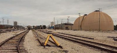
|
Today, the former Indian village has been replaced by Milwaukee’s largest sewage treatment plant, mountains of road salt, boxcars and railroad tracks, lift docks, warehouses, petroleum tanks, and a tiny park that commemorates the days when Native Americans made it their home. |
* Root river which enters lake Michigan at Racine.
* Maj. Daniel Baker, a native of Vermont, entered the service as an Ensign in Jan., 1799; became an adjutant in 1802; first lieutenant in 1806; a Captain in March, 1812, and for distinguished services in the battle of Maguago, in which he was wounded, was brevetted Major; distinguished in the affair at Lyon's Creek; promoted to major in 1814, and Lieut. Colonel in 1829; commanded a regiment in the battle of Bad Axe in 1832; and died at Detroit, October 10, 1836.
* The river Chicago was first explored by La Salle and Hennepin in 1679 I have been led into many errors from the misapplied names and antiquated style of hennepin1 s narration he calls lake Michigan the lake of the Illinois and Chicago the river Miamis time must have made a great alteration in this region or both Hennepin and la Salle have erred egregiously in the description of it the triangular eminence naturally fortified at the mouth of the Chicago, and the distance of twenty-five leagues from the portage between the Chicago and the Illinois to the confluence of the former with the lake induce a belief that neither of them were there La Salle in his letter to Count Frontenac errs in his description of the ground between the Chicago and Illinois or as he calls it the divine river
*Mr. Storrow errs here; the River Miamis, at the mouth of which was the
triangular eminence, was what is since called the St. Joseph. see Spark's
life of La Salle
© Every submission is protected by the Digital Millennium Copyright Act
of 1998. Show your appreciation of this freely provided information by not
copying it to any other site without our
permission.
Become a Clark County History
Buff
A site created and
maintained by the Clark County History Buffs
Webmasters: Leon
Konieczny, Tanya Paschke,
Janet & Stan Schwarze, James W. Sternitzky,
![]()
and supported by your generous donations.